Pallikaranai Marsh's RAMSAR Status and the 1km Buffer: What It Means for Land Valuation in Chennai
By Harihar S, Chartered Engineer & IBBI Registered Valuer
From Reserve Forest to Ramsar Site
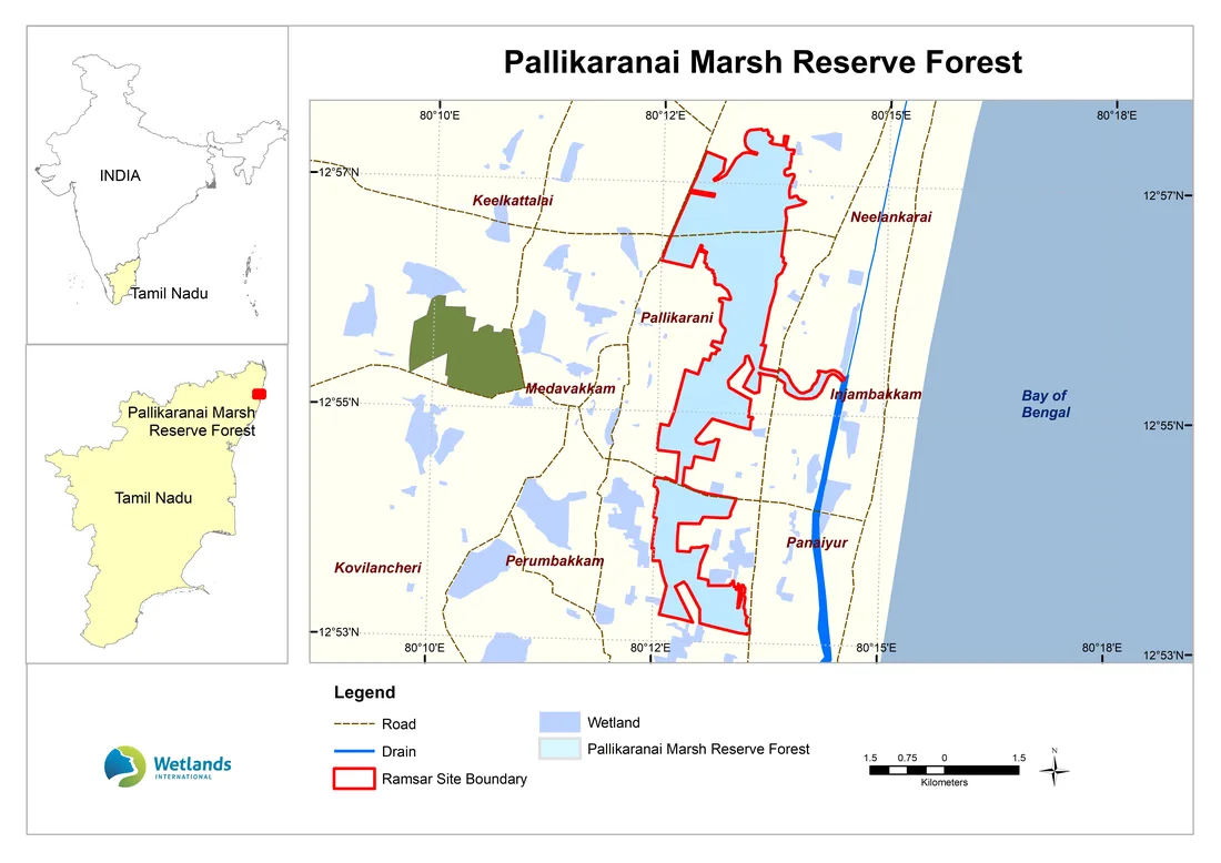
Pallikaranai Marsh, in south Chennai, is one of the few surviving natural wetlands in a rapidly urbanised metropolitan region. Land was transferred to the Tamil Nadu Forest Department in stages: 317 hectares as Reserve Land under G.O.Ms. No.52, Environment & Forests Department (9 April 2007), 170.40 hectares under G.O.Ms. No.127, Municipal Administration & Water Supply Department (24 December 2012), 131.55 hectares declared under Section 26 of the Tamil Nadu Forest Act, 1882 (Kancheepuram District Gazette, 1 July 2013), and 75.93 hectares under G.O.Ms. No.147, Revenue Department (12 May 2014). On 8 April 2022, a larger area covering 1,247.54 hectares was designated a Wetland of International Importance under the Ramsar Convention, listed as Ramsar site number 2481. That international designation carries a domestic conservation obligation: the wetland and the land around it fall under the Wetlands (Conservation and Management) Rules, 2017, administered through the Tamil Nadu State Wetlands Authority (TNSWA), which restricts activities such as construction, encroachment and reclamation within the notified boundary.
OA No. 91 of 2023 (SZ): How This Started
The current legal position traces back to a single incident. In June 2023, a news report described a private builder laying an access road and dumping construction material inside marshland in Perumbakkam, a locality that feeds into the main Pallikaranai marsh. The National Green Tribunal's Southern Zone bench at Chennai took up the report suo motu as Original Application No. 91 of 2023 (SZ), impleading CMDA, the Chengalpattu District Collector, the Tamil Nadu State Wetlands Authority (TNSWA) and, later, the developers involved.
Over two years of status reports, the case established some genuinely useful facts for anyone valuing land in the area. The disputed survey numbers, such as 286/1 and 286/2 in Perumbakkam, were confirmed by the District Collector's own revenue records going back to 1911 as validly held Ryotwari patta wetlands, never classified as government poromboke. TNSWA's inspections separately measured the original suo motu site at roughly 150 metres from the Ramsar boundary and a related survey number, Sy. No.286, at roughly 247 metres, both within what it calls the marsh's "zone of influence". In other words: this was not a case of encroached government land, but of clearly titled private land that still fell inside a hydrologically sensitive zone.
Read the order itself: official NGT PDF or the more readable Indian Kanoon transcript.
What the NGT Actually Ordered, and Where It Stands Today
On 24 September 2025, the NGT's bench of Justice Pushpa Sathyanarayana and Dr. Prashant Gargava disposed of OA No. 91 of 2023 (SZ) by directing the Water Resources Department, TNSWA and CMDA to work in coordination to expedite an Integrated Management Plan (IMP) for the Ramsar site, and holding that no approvals or permissions that could alter the marshland's character should be granted until that IMP is in place.
The often-quoted "1km zone of influence" is not a fixed legal buffer written into the order. It comes from an earlier Integrated Management Plan prepared by Care Earth Trust, a Chennai-based environmental research organisation that has studied the marsh since the early 2000s, using a Direction Model and Buffer Model, and TNSWA's own submissions in the case describe it as "not a fixed or uniform area", one that still needs proper scientific delineation based on local hydrology, drainage and topography. That delineation is now being carried out by the National Centre for Sustainable Coastal Management (NCSCM) as part of a revised IMP.
CMDA's practical response has been to withhold fresh building plan approvals within the 1km zone of influence; the Tamil Nadu government told the Madras High Court that 47 such applications were pending as of mid-2026. CREDAI Chennai and individual realtors have challenged this restriction before the Chief Justice's bench, Chief Justice S.A. Dharmadhikari and Justice G. Arul Murugan, arguing it was imposed without a proper scientific study and is arbitrary. On 20 August 2026, TNSWA placed NCSCM's proposed variable-width interim buffer map on record before the court, and the parties were given time to examine it, suggesting the court may be moving toward a scientifically graded boundary rather than a uniform 1km freeze. As of this writing, no final order has been passed. Because this is an active, fast-moving case, always confirm the current status directly with TNSWA, CMDA or legal counsel before relying on any of these details for a live transaction.
What This Means for a Property's Value
CREDAI has argued before the Madras High Court that more than 1.2 lakh patta landowners are affected, a figure advanced in support of its case rather than an independently verified count. A separate spatial analysis of government FMB records, reported by a Chennai real estate industry publication, put the number of existing buildings inside the wider 1km zone at roughly 57,480, including close to 20,000 residential structures. Whatever the precise count, none of this changes who legally owns the land, as the NGT case itself confirms for the Perumbakkam survey numbers it examined. What it changes is what that ownership is worth in practice, in three specific ways a valuation report needs to address:
| Effect | What it means in practice |
|---|---|
| Marketability | The pool of willing buyers shrinks sharply once fresh building plan approval becomes uncertain. Land with an existing structure can still change hands, but redevelopment, extension or new construction is on hold until the IMP and the Madras High Court proceedings resolve. |
| Bankability | Banks and NBFCs treat land inside the notified boundary or the provisional zone of influence with far more caution as fresh collateral, and existing NPA collateral in the area needs to be revalued against the current approval uncertainty, not priced as ordinary developable land. |
| Liquidation / NCLT realisability | For a resolution professional selling land in this corridor within a time constrained process, realisable value is likely to diverge sharply from book value or the last registered transaction, given the approval uncertainty and pending litigation. |
The underlying point for anyone commissioning or relying on a valuation here: clear patta and registered title, on their own, do not mean a parcel is unaffected. Land bought or inherited well before the 2022 Ramsar notification or the 2025 NGT order can still fall inside the notified boundary or the zone of influence drawn around it.
Verifying Wetland Status Before Valuing
Axium's document-to-site verification workflow for Tamil Nadu property, title records, land records, physical inspection, encumbrance and comparable transactions, guideline value and zoning, applies here too, with one addition for land in or near a notified wetland. TNSWA's own submissions before the NGT identify 304 survey and subdivision numbers across seven revenue villages, Perumbakkam, Sholinganallur-1, Pallikaranai, Perungudi, Jalladianpet, Injambakkam and Okkiyam Thoraipakkam, as falling within the notified Ramsar boundary itself. The site's official Ramsar Information Sheet separately describes the marsh as bordered by the Old Mahabalipuram Road corridor and the residential areas of Perungudi, Siruseri, Pallikaranai, Madipakkam, Velachery and Taramani, a useful starting list of nearby localities worth checking even where a specific survey number doesn't appear on the boundary list. Before a value is assigned, the parcel's survey number is checked against the official list and the current TNSWA and CMDA boundary maps, and the status of the pending Madras High Court proceedings is confirmed. Where a parcel falls inside a notified or contested boundary, that is recorded in the report as a limiting condition affecting marketability and bankability, rather than priced as ordinary freehold developable land.
See the Boundary Yourself (Unofficial Reference)
For a quick visual check of where the marsh boundary runs relative to a location you're looking at, we've put together a KMZ file you can open in Google Earth or Google Maps. This is a hand-digitized reference sketch for illustration only, not the official notified boundary, so it should never be relied on to certify whether a specific parcel falls inside or outside the line. Always confirm the current official boundary with TNSWA or CMDA before a transaction or valuation decision. For the map issued by CMDA itself, see CMDA Office Order 07/2025 and the official influence area map.
Download reference boundary (KMZ, unofficial)
To view it:
- Google Earth Pro (desktop, free): File → Open, and select the downloaded file. It loads as a temporary layer over satellite imagery; File → Save → Save My Places keeps it permanently.
- Google Earth Web (earth.google.com/web, sign in required): Projects → New Project → Import KML file, then upload the downloaded file.
- Google My Maps (mymaps.google.com): Create a new map, Import, and upload the file to view it as an interactive 2D overlay you can share or embed.
Does This Apply to Other Wetlands in India?
The same underlying logic, a Ramsar or state notified wetland boundary and an associated buffer or zone of influence that restricts construction, applies wherever a similar notification exists, such as Vembanad in Kerala, Chilika in Odisha, or the East Kolkata Wetlands. The specific boundary, buffer distance and administering authority differ by site and state, so this is a check worth making for any land near a notified wetland, not only around Pallikaranai.
Why Axium Valuation
Axium Valuation Services LLP is an IBBI registered valuer (IBBI/RV-E/04/2021/144, Land & Building) with 15+ years of experience in real estate valuation across Tamil Nadu and pan-India. Flagging title, use and regulatory restrictions such as this one is part of every real estate valuation Axium prepares for banks, NCLT resolution and liquidation proceedings, and M&A due diligence.
Frequently asked questions
Is land within Pallikaranai Marsh's zone of influence still legally owned and saleable?
Yes. Patta and registration are not affected by the NGT's order in OA No. 91 of 2023 (SZ) or the Ramsar notification, and the NGT itself confirmed that the Perumbakkam survey numbers it examined are validly held private patta wetlands, not encroached government land. What has changed is that CMDA now applies far more caution to fresh building plan approvals in and around the notified boundary, pending the Integrated Management Plan and the Madras High Court proceedings. That does not change ownership, but it materially affects marketability, bankability and the price a willing buyer will actually pay, which a valuation report has to reflect.
Has the Madras High Court lifted the NGT's restrictions around Pallikaranai Marsh?
Not as of September 2026. CREDAI and individual realtors have challenged CMDA's approach to approvals since the NGT's order of 24 September 2025 in OA No. 91 of 2023 (SZ), and the matter is pending before the Chief Justice's bench. The Tamil Nadu State Wetlands Authority placed NCSCM's proposed variable-width interim buffer map before the court on 20 August 2026, and the court has given parties time to examine it. Until a final order is passed and the Integrated Management Plan is approved, the current cautious approach to approvals continues. Given the case is active, confirm the current status directly with TNSWA or CMDA before relying on it for a live transaction.
Does this issue only affect Pallikaranai, or should I check for it elsewhere in India?
The same logic applies to any land near a Ramsar-notified wetland or within a state notified eco-sensitive or no-development zone, such as Vembanad in Kerala, Chilika in Odisha, or the East Kolkata Wetlands. The specific notified boundary, buffer distance and authority differ by site and state, so this needs to be checked for any parcel near a notified wetland, not only in Chennai.
Partner with Axium for expert valuation services
Have questions first? Call +91-8939-891329
Not ready yet? Browse our Resources for guides on IBBI registration and fee schedules.