
Is Your Plot Inside the Pallikaranai Ramsar 1km Influence Area? What CMDA's Order 07/2025 and Map Show
By Harihar S, Chartered Engineer & IBBI Registered Valuer
What CMDA Office Order 07/2025 Says
Our earlier article on Pallikaranai Marsh's Ramsar status covers the National Green Tribunal's order and its valuation impact. This article looks at the administrative order that put it into practice at CMDA, because that is the document, and the map attached to it, that a landowner or lender can actually check a plot against.
| Item | What the order records |
|---|---|
| Issued by | Chennai Metropolitan Development Authority, Administration Division |
| Order number and date | Office Order No. 07/2025, dated 09.10.2025 (signed by the Principal Secretary / Member Secretary on 03.10.2025) |
| Effective from | 06.10.2025 |
| Subject | Approvals, sanctions, or permissions for developments in the RAMSAR Site boundary and its influence area |
| Instruction | "It is instructed not to grant any approvals/permissions in the RAMSAR Site boundary and its influence area as per the map enclosed herewith." |
| Enclosure | "RAMSAR Site Boundary and influence area map" |
| Addressed to | Internal CMDA divisions and units, for compliance |
The order explains its background in one paragraph: the National Green Tribunal took up a suo motu case based on a New Indian Express report of 30.06.2023 titled "Road being laid inside marshland in Perumbakkam", and ordered "the authorities not to grant any approvals/permissions in the RAMSAR Site boundary and its zone of influence of 1 km." The order does not cite a case number, but the description matches OA No. 91 of 2023 (SZ), the case we cover in the earlier article.
What the Order Does Not Say
Press coverage often calls this a "construction ban". The order's own text is narrower, and the difference matters when you are deciding what applies to a specific plot.
- It instructs CMDA not to grant approvals and permissions. It does not mention existing buildings or structures.
- It does not mention sale, registration of documents or bank lending against land in the area.
- It does not define the influence area in words. The area is defined by the enclosed map, and the "1 km" figure appears in the NGT direction the order quotes.
That does not mean those questions are settled in either direction. It means this order does not answer them. The wider effect on marketability and bankability is what our valuation-impact article examines. For a live transaction, confirm the position on a specific parcel with CMDA, the Tamil Nadu State Wetlands Authority (TNSWA) or legal counsel.
The Ramsar Site and Influence Area Map
This is the map enclosed with the order, reproduced from CMDA's published copy. The legend distinguishes five things: village boundaries (orange lines), survey parcels (thin black outlines with numbers), the Pallikaranai swamp area (dark red), the Ramsar site boundary (pink) and the Ramsar site influence area of 1km (yellow).
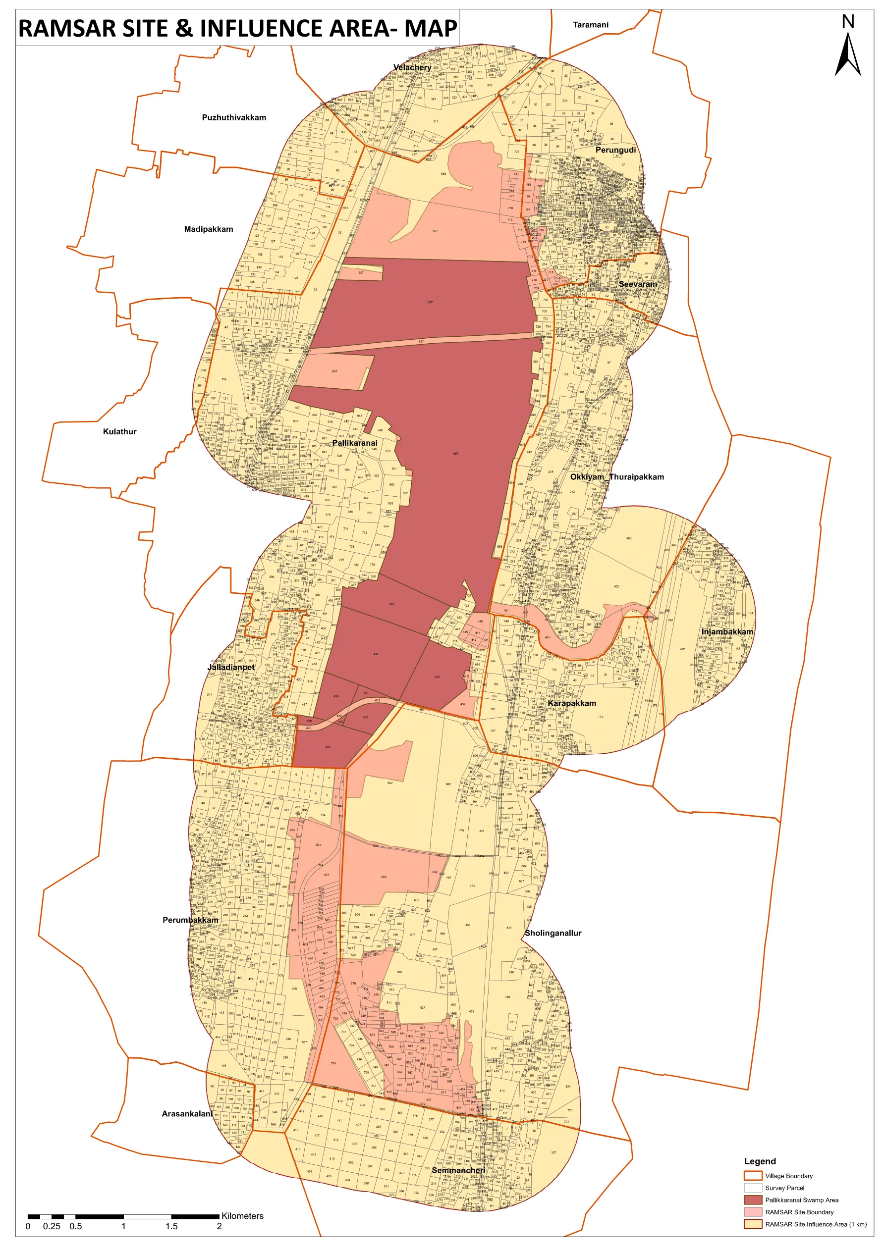
Villages labelled on the map: Velachery, Puzhuthivakkam, Madipakkam, Kulathur, Pallikaranai, Jalladianpet, Perumbakkam, Arasankalani, Semmancheri, Sholinganallur, Karapakkam, Okkiyam Thuraipakkam, Injambakkam, Perungudi and Seevaram. Taramani is also labelled at the top edge of the map. Several villages appear only partly inside the shaded area, so a village name on its own does not tell you whether a parcel is affected.
Order and map on the CMDA website (PDF)
We also host a copy of the same file as published by CMDA, in case the link moves: CMDA Office Order 07/2025 with map (PDF, 2 pages). The PDF is vector-based, so you can zoom in far enough to read individual survey numbers.
How to Check a Plot Against the Map
- Get the village and survey number. Take the village name and the survey or sub-division number from your patta, chitta, encumbrance certificate or sale deed.
- Find the village on the map. Zoom to the village label and its orange boundary. The same survey number can exist in more than one village, so match the number only inside the correct village's boundary.
- Read the shading. Dark red is the swamp area, pink is the Ramsar site boundary, yellow is the 1km influence area, and unshaded parcels fall outside all three.
- Do not self-certify near an edge. If the parcel touches or straddles a boundary, or you cannot read the number with confidence, treat it as unconfirmed and ask CMDA or TNSWA to confirm in writing.
- Check the current legal position. The Madras High Court proceedings are still open, so confirm nothing has changed since the map was issued.
Axium's document-to-site verification workflow includes this check for land in and around the marsh. Where a parcel falls inside the mapped area, we record it in the report as a limiting condition affecting marketability and bankability, not as ordinary developable land. You can also see our real estate valuation service.
The Map Shows a Uniform 1km Zone, and a Different Boundary Is Proposed
The map above reflects the uniform 1km influence area as issued in October 2025. TNSWA has reportedly placed a variable-width interim buffer map, prepared by the National Centre for Sustainable Coastal Management (NCSCM), before the Madras High Court, and the court has given the parties time to examine it. That is a proposal, not an adopted boundary, and the CMDA order and map remain the reference until an authority or the court changes them. If a different boundary is adopted, a revised map would replace this one. We track the case in our main article and will update this page if the position changes.
Why Axium Valuation
Axium Valuation Services LLP is an IBBI registered valuer (IBBI/RV-E/04/2021/144, Land & Building) with 15+ years of experience in real estate valuation across Tamil Nadu and pan-India. Flagging title, use and regulatory restrictions such as this one is part of every property valuation Axium prepares for banks, NCLT resolution and liquidation proceedings, and M&A due diligence.
Frequently asked questions
Does CMDA Office Order 07/2025 ban construction near Pallikaranai Marsh?
It instructs CMDA officers not to grant any approvals or permissions in the Ramsar site boundary and its influence area as per the map enclosed with the order, with effect from 06.10.2025. Its text is about the approvals CMDA may grant. It does not mention existing buildings, sale, registration or lending, so those questions are not answered by the order itself. Confirm the position for a specific parcel with CMDA, TNSWA or legal counsel.
How do I check whether my survey number is inside the Pallikaranai Ramsar influence area?
Find your village and survey or sub-division number on your patta, chitta or sale deed. Open the official map enclosed with CMDA Office Order 07/2025, zoom to your village, and find the survey number inside that village's orange boundary, because the same number can appear in more than one village. Then note whether the parcel is shaded dark red (swamp area), pink (Ramsar site boundary), yellow (1km influence area) or unshaded. If the parcel sits on or near an edge, treat it as unconfirmed and ask CMDA or TNSWA to confirm.
Which villages does the CMDA Ramsar influence area map cover?
The map labels Velachery, Puzhuthivakkam, Madipakkam, Kulathur, Pallikaranai, Jalladianpet, Perumbakkam, Arasankalani, Semmancheri, Sholinganallur, Karapakkam, Okkiyam Thuraipakkam, Injambakkam, Perungudi and Seevaram. Several of these appear only partly inside the shaded area, so a village name alone does not tell you whether a parcel is affected. Check the survey number on the map.
Is the 1km influence area on the CMDA map the final boundary?
Not necessarily. The map reflects the uniform 1km zone as issued in October 2025. NCSCM has proposed a variable-width interim buffer, which was reportedly placed before the Madras High Court on 20 August 2026 and has not been adopted as of this writing. If a different boundary is adopted, a revised map would replace this one, so check the current position before relying on it.
Partner with Axium for expert valuation services
Have questions first? Call +91-8939-891329
Not ready yet? Browse our Resources for guides on IBBI registration and fee schedules.